Balfour | Boswell
| Castlegar | Crawford
Bay | Creston |
Christina Lake | Grand
Forks | Gray Creek | Greenwood
| Kaslo | Kootenay
Bay | Nakusp | Nelson
| New Denver | Riondel
| Rossland | Salmo
| Silverton | Slocan
| Trail
BALFOUR
The town of Balfour is a resort community with accommodation,
camping, marinas, and a full range of fishing services. Balfour
can be reached along Highway 3A east of Nelson or by travelling
south from Kaslo on Highway 31.
BOSWELL
The
highway winds through this quiet community, on the East side of
Kootenay Lake, providing dramatic vistas of towering mountains
and sparkling water.
CASTLEGAR
Located on the southern tip of the Arrow Lakes chain, at the confluence
of the Kootenay and Columbia Rivers, Castlegar is a perfect base
for a whole range of outdoor activities: hiking, water sports,
fishing, and canoeing.
CHRISTINA LAKE
Christina Lake is one of the warmest and clearest lake in BC,
serving up delicious summertime fun. The lake is 19 km. long and
more then 180 meters deep in some sections.
CRAWFORD
BAY
Crawford Bay, on Kootenay Lake, has a beautiful sandy beach and
marina. Accommodations include motel, lodge, an historic country
inn, cabins, and an RV Park & campground, with the Community
Park and mini-golf nearby.
CRESTON
Creston overlooks a broad, fertile valley where the Kootenay River
meanders between the Selkirk and Purcell mountains, and can be
reached by Highway 3, east of Salmo and west of Cranbrook Visitors
can enjoy golfing, fishing, hunting, hiking, cross-country skiing,
and birdwatching.
GRAND
FORKS
Grand Forks is an attractive valley town named for its location
near the convergence of the Kettle and Granby Rivers, on Hwy 3,
west of Castlegar and east of Osoyoos. Offers a swimming pool,
skating rink, picnic sites, hiking, cross country & downhill skiing,
hunting, and waterskiing.
GRAY CREEK
The community of Gray Creek, first settled in 1906, is located
ten kilometres south of Crawford Bay on the East shore of Kootenay
Lake. If you like history, stop at Kootenay Lake's oldest general
store.
GREENWOOD
Nestled in the mountains east of Osoyoos and west of Grand Forks,
Greenwood is now Canada's smallest city, but when it was incorporated
in 1897 it was a mining boom town. Many turn-of-the-century buildings
in this picturesque community have been restored.
KASLO
A product of the silver bonanza of the 1890's, Kaslo is set on
a delta of the Kaslo River, between the Selkirk and Purcell Mountains.
Follow Highway 31 north of Balfour or Highway 31A south of New
Denver. Visitors enjoy golfing, boating, fishing, camping, hiking,
hot springs, and swimming.
KOOTENAY
BAY
The ferry terminal on the east shore of Kootenay Lake, Kootenay
Bay offers restaurants and accommodations in motel, cabins, B&B
or a private campground. Excellent hiking trails begin just a
few kilometres away at Pilot Bay.
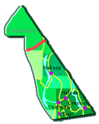
NAKUSP
Located 47 km. (29 miles) north of New Denver on Highway 6, Nakusp
is central to 230 km of lakes from Revelstoke to Castlegar. Golf,
hiking, fishing, and skiing provide visitors with year round enjoyment.
NELSON
Located on the West Arm of Kootenay Lake, Nelson is home to 350
heritage buildings. This charming city offers lots to see and
do: fishing, boating, sailing, swimming, hiking, cycling, golfing,
and skiing.
NEW
DENVER
Set on the northeastern shore of Slocan Lake, and located at the
junction of Highways 31A and 6, 47 km. northwest of Kaslo, New
Denver is a busy center for hikers, anglers, boaters, skiers,
and snowmobilers.
RIONDEL
Located on the east shore of Kootenay Lake, Riondel has a population
of approximately 400 people, a lakeshore campground, beach, community
centre, playground, 9-hole golf course, grocery and liquor store,
cafe, pub and medical clinic.
ROSSLAND
This cozy community tucked into the Monashee Mountain Range, only
6 km north of US border on Highway 3B, is literally surrounded
by recreation, including a world class ski hill, cross country
ski trails, hiking, golf course, skating rink, mountain biking,
snowmobiling, and swimming pool.
SALMO
Salmo is located 43 km east of Castlegar at the junction of Highway
3 and 6. The streets and 1930's architecture of downtown are being
revitalized. Salmo offer a golf course, hiking, cross-country
& downhill skiing, fishing, hunting, and gold panning.
SILVERTON
Silverton is located on the eastern shore of Slocan Lake. This
historic mining town is noted for trail rides, pack trips, fishing,
golf, tennis, horseback riding, canoeing, boating, and biking.
SLOCAN
Located south of Silverton, Slocan was established in the 1890's
after prospectors discovered large silver-lead deposits. Hiking,
boating, fishing, downhill & cross-country skiing, golfing, kayaking,
canoeing, and rock climbing are popular activities.
TRAIL
The city of Trail is located on the Columbia River, 27 km. (17
miles) south of Castlegar on Highway 3B. Home to the Cominco lead
& zinc smelter, Trail offers a swimming pool, skating arena, curling
rink, cross country and downhill skiing, golfing, hiking, fishing,
boating.
|