Travel
the Chilcotin Highway 20 west from Williams
Lake, British Columbia, to Bella Coola on the Central
Coast and experience a view of modern ranching and logging
as well as a step back into the early days of the Chilcotin
Country.
The
Chilcotin is a magnificent land offering vacationers a variety
of activities; from river
rafting and fishing to camping and wildlife
viewing. Or, experience a complete western adventure
at a guest ranch or
lodge.
One
of British Columbia's last frontiers, the Chilcotin and
BC's Central Coast has something for everyone. Memories
in the making.
Loran
C. Tower
About 23 km (14 mi.) west of Williams Lake you will cross
the Mighty Fraser River on the Sheep
Creek Bridge. The steep Sheep Creek Hill climbing up
from the bridge can afford you a spectacular view of the
entire area. 13km. (8mi.) from the bridge you will come
across a strange site of towers and flashing lights on the
north side of the highway. This is the Loran Tower which
is a maritime navigational tower. It is open to the public
at certain times or tours can be arranged.
This
first small community you arrive at, Riske Creek is situated
about 52 km (32 mi.) west of Williams
Lake, and is the gateway to a vast number of adventures
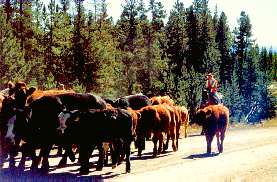
in the Chilcotin. Although the earliest activity in the
area was trading, the 1860's saw cattle ranchers arrive.
The village of Riske Creek is the site of one of the earliest
ranches in the area owned by a Polish gentleman, L.W. Riskie.
Ranching and logging remain as the main industries of the
area. With the amenities such as gas, lodgings and general
store available this is the ideal spot to begin a Chilcotin
adventure. The history of the area can be relived in the
summer Riske Creek Rodeo and Frontier Days, while modern
day sites and adventures can begin at this spot.
A
number of day trips originate in Riske Creek; turn off Highway
20 just east of Riske Creek. You will have a good chance
of spotting Big
Horn Sheep at nearby Junction Sheep Reserve (15 km (9
mi.), another 5 km (3 mi.) will bring you to the spectacular
Farwell Canyon.
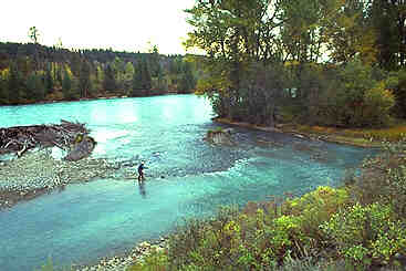
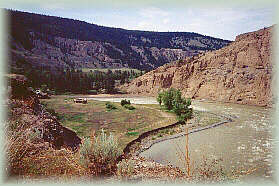
At Farwell Canyon, near the junction of the Chilcotin and
Fraser Rivers, you will be awed by the magnificence of the
freestanding sandstone formations, the hoo-doos; be touched
by the history brought to life by the Indian pictographs
on nearby cliffs; feel the excitement of river rafters buffeting
their way down the river rapids; experience the thrill of
watching the native fishermen dipnetting for salmon.
From
Farwell Canyon you can wind your way on good gravel to the
tiny community of Big Creek and then onto some fishing,
camping or boating at the BC Forest Service Campsite on
Fletcher Lake. From Fletcher Lake the road takes you to
Highway 20 and historic Hanceville which is located on the
site of an early ranch belonging to Tom Hance. While accessing
all the modern amenities of restaurant, store, laundramat
and post office, you can admire the distant view of spectacular
snowcapped mountains. Click
here for a list of accommodation/adventure providers in
this area.
The
small town of Hanceville, BC, is known for the infamous
Lee's Corner, where Norman Lee, a cattle rancher attempting
to push his herd almost 2500 km (1550 miles) through the
wilds, met fate. During the journey his horses died, leaving
him to carry on by foot. As winter closed in Norman Lee
had to butcher his herd. Fortunately, he survived the ordeal
and his book, "Klondike Cattle Drive" outlines,
in detail, the event. The area surrounding Hanceville provides
spectacular view and landscapes. Plunging canyons, rivers
and sandstone and lava formations are just some of the natural
attractions this area has to offer.
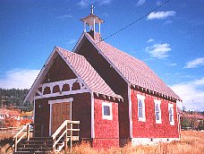
Travelling
west from Hanceville on Highway 20 brings you to the community
of Alexis Creek, named after Chief Alexis, chief of the
Chilcotin Indians. This settlement services the area with
the RCMP station, a Red Cross Station,
church, British Columbia Forest
Service office and school as well as post office, store
and gas station.
There
are a number of nearby lakes suitable for fishing, boating
and swimming with skiing and skidooing in the winter.
The
community of Tatla Lake
is located 122 km (76 miles) west of Alexis Creek on Highway
20 and offers accommodation, food and other necessary supplies.
Situated on the edge of the Chilcotin Plateau, this area
provides access to wilderness fly-in lakes and rivers, nordic
ski trails and excellent mountain
hikes.Plantlife
is varied and ranges from old-growth Douglas
fir, western hemlock, red cedar, heathers and dry grass
species. There are several resorts and guiding operations
in the area. Click
here for a list of accommodation/adventure providers in
this area.
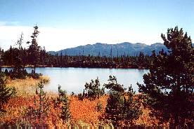
Nimpo
Lake, also known as the float plane capital of B.C.,
is a popular destination for families and fishers alike.
Nimpo Lake is a scenic 12 km (7 mi.) long lake, with Mt.
Kappan in the background, has many resorts and offers a
variety of summer and winter activities. Some of the best
rainbow fishing as well as boating, swimming, hiking and
hunting are just some of the attractions for visitors to
the Nimpo Lake area.
5
km (3 mi.) from Nimpo Lake is a BC Forest Service Recreation
Site which is popular for canoeing and nature viewing.
The
Lessard Lake Road,
approximately 18 km (11 mi.) west of Nimpo Lake will take
you along the Dean
River, famous worldwide for its Steelhead. The majestic,
multi-coloured Rainbow Range, from which obsidian (volcanic
glass) is obtained, is also visible. The early Chilcotins
used to trade in this commodity which could make extremely
sharp tools. Click
here for a list of accommodation/adventure providers in
this area.
Anahim
Lake was named after a Chilcotin chief. There have been
mentions of a "Lake Anawhim" by travellers in
the mid 1800s.
Home
of the "Old Fashioned Wild West Rodeo" each July,
Anahim Lake and area offer interesting sights and activities
for the visitor. It is also the last community before entering
Tweedsmuir Provincial Park;
an outdoor person's "heaven". Closer to the community
there are a number of lodges and resorts that cater to the
fisher, hunter, hikers or those who want organized pack
trips or mountain rides. Float planes will take you to a
myriad of nearby wilderness experiences.
Nearby
Anahim Mountain offers a bit of history plus a spectacular
view of a pillared cone of volcanic rock; this is another
site for obsidian, the important trading commodity for the
Chilcotins as it was used extensively for weapon making.
A Forest Service Recreation site on Little Anahim Lake offers
an idyllic spot for canoeing, picnicing and waterfowl observation. Click
here for a list of accommodation/adventure providers in
this area.

 Anahim
Lake
Anahim
Lake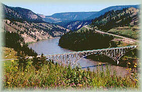