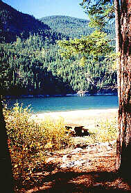
Syringa Creek Provincial Park, Lower Arrow Lake, British Columbia. Syringa Creek Provincial Park, BC


Lodging & Services
Recreation
Cities & Towns
Lakes
Travel Info
Points of Interest
Provincial Parks
Trails


Syringa Creek Park

Syringa Creek Provincial Park is a 152 hectare park that encompasses the southeastern end of the Lower Arrow Lake Reservoir in the Norns Range of the Columbia Mountains. Here on the steep mountainside evidence of the Canadian Pacific Railway is still visible.

The Syringa Creek is named for the shrub syringa or mock orange which is native to the area.


LOCATION
The park is located in the Kootenays 19 km off of British Columbia Highway 3. The city of Castlegar is the closest centre.
 

PARK FACILITIES & ACTIVITIES
Camping - The 60 site campground at Syringa Creek Provincial Park provides water, wood and toilets. Picnic grounds are located at the north and south ends of the park. Good swimming beaches and changehouses are found nearby.

Syringa Park BeachFishing & Boating - There are two boat launching ramps available at Syringa Creek Provincial Park.

The Lower Arrow Lake provides the avid angler with the opportunity to catch rainbow trout, Dolly Varden and kokanee.

Hiking & Trails - A trail leads through the park from the campground to the north picnic ground.

Information & Services
If you would like to have your business listed, please Click Here.


www.bcadventure.com

British Columbia Adventure Network © 1995 - 2024 Interactive Broadcasting Corporation

Plan a Vacation
Lodging & Services: more info
Accommodations Adventures Attractions
Events Dining & Entertainment Shopping
Transportation Conference Centers Publications & Media
Recreation: more info
Attractions ATV Boating
Camping Canoeing & Kayaking Dog Sledding
Fishing Golf Guest Ranches
Health/Spas Cat & Heli-Skiing Hiking
Houseboating Mountain Biking Mountain Climbing
Multisport Natural Hot Springs River Rafting
Skiing Snowmobiling
Regional Information
Cities & Towns Lodging, Hotels, Services & Events . . more info
Lakes Resorts, Cabins, Fishing Info, Maps . . more info

Travel Info Travel Journals, Tourist Info Centers, Weather, Road Conditions, BC Ferries Info, Travel Planner . . more info

Points of Interest . . more info
Provincial Parks . . more info
Trails Hiking & canoeing trails . . more info

Area Maps of the Kootenays
Upper Arrow Hwys 23 & 31:
Nakusp & Area
Lower Arrow, Slocan & Kootenay Lakes Hwys 6 & 31:
Central Kootenay Monashees (to Lumby)
Hwys 6 & 3:
South Kootenay Boundary (Southern Route to Okanagan)


Advertise With Us

Promote your business on the BC Adventure Network.
BC's largest and most visited tourism Web site . . . more info.

Advertising Inquiries:
advertising@ibcnetwork.com

© 1995 - 2018 Interactive Broadcasting Corporation


Follow Us On Facebook


List of BC Adventure
Advertisers

Site Info
Advertise With Us
Awards
About Us
Contact Us


Free Vacation Guides
BC Vacation Guides
Coastal Vacations
Thompson Okanagan
EcoTourism
Fishing Vacations
Guest Ranch Guide
Romantic Getaways
Wilderness Vacations
Winter Vacations
The Rockies Guide


Login


Syringa Creek Provincial Park, Lower Arrow Lake, British Columbia. Syringa Creek Provincial Park, BC