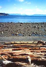
The
Island Highway (Hwy 19) begins in Nanaimo and continues north
for 390 km (242 miles) to Bear Cove. The route to
Campbell River (152 km or 94 miles) is a pleasant
journey through forested landscape and rolling
hills,with views of the Strait of Georgia, the Gulf
Islands and the Coast Mountains. Excellent accommodation
is found along the way.
Stops along this northern route include
Lantzville, Nanoose Bay, Brant Goose Feeding Area (a
rest and feed area for migratory waterfowl), Rathtrevor
Beach Provincial Park (one of the island's most
popular camping spots), Englishman River and
Parksville.
Parksville:
Named after its first settler and postmaster, Parksville
offers the visitor over 1.5 km (1 mile) of sandy beach,
salmon and trout fishing in the Englishman and Little
Qualicum Rivers, as well as various resorts
and tourist facilities. Interesting spots
nearby include the Coombs Country Market and Emporium,
Cathedral Grove and the Wild Rhododendron Reserve.
Lasqueti Ferry to Lasqueti
Island: Popular with bikers and paddlers, access
to Lasqueti Island is via a foot passenger ferry just
off of Hwy 19 at Lee Road.
Qualicum
Beach: This retirement and
tourist spot is known for good salmon
fishing, beach combing and golfing.
Great beaches, specialty shops and galleries are just
some of its attractions. Qualicum Beach is located 47 km
(29 miles) north of Nanaimo. Take Hwy 4A as an
alternative scenic road from Hwy 4 to Port
Alberni and the west coast of the island.
61 km (38 miles) north of Nanaimo
is the Horne
Lake Road which leads west to the Spider Lake
Provincial Park and Horne Lake Caves Provincial Park.
Two self-guided and three guided tours are available to
the caves. Continuing north you will pass communities
including Bowser, Deep Bay, Rosewell Creek Provincial
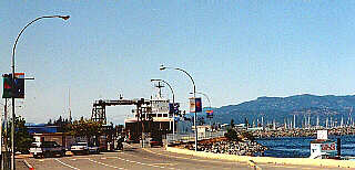
Park and Fanny Bay. A car and passenger ferry to Denman
Island (and from Denman onto Hornby) is located at
Buckley Bay.
Cumberland: Founded
in 1888 by Robert Dunsmuir, this once prosperous coal
mining town offers a glimpse into its historic past
through ancient buildings in the Chinatown area. Other
historic buildings still in use include those housing
the hospital (1894) and the post office (1907). The last
coal mine closed in 1966 and now the town is a peaceful
resort village offering access to the beautiful valley
surrounding. Turn west on the Cumberland road 102 km
(63miles) past Nanaimo. Continuing past Cumberland,
visitors will reach Comox Lake and Lakes Chain. Or
return to Hwy 19 and continue north.
Courtenay
and Comox:
Located mid-island in a fertile valley which backs into
impressive mountains, Courtenay-Comox is 107 km (66
miles) north of Nanaimo. White settlers from the Hudson
Bay Company first arrived in 1860 with farming interests
in the area. A Canadian Forces Base is located here.
CFB Comox:
Opened in 1942, this base specializes in sea-air rescue
and maritime patrol. Heritage aircrafts including a DC3
Dakota, a CF-100 Canuck, a CF-101 Voodoo, a CF-104
Starfighter and a CP-107 Argus may be seen here.
Courtenay and District Museum
and Archives:
Exhibits include native, Chinese and Japanese culture
and logging and farming equipment may be found in the
Native Son's Hall, located at 360 Cliffe Avenue.
Forbidden Plateau:
This down hill and cross country ski area
is in Strathcona
Provincial Park. During the summer months the
lodge is used by guests enjoying good alpine
fishing and hiking. It is a 25 minute drive from
Courtenay.
Mt. Washington Ski Areas:
This famous ski area is located 31 km (19 miles)
west of Courtenay and provides guests with nordic and
downhill skiing opportunities as well as brilliant
mountain and forest views.
Further north on Hwy 19 is the
Miracle Beach Provincial
Park with good camping facilities. Turn east off
of the highway 24 km (15 miles) north of Courtenay.
Mitlenatch Island Provincial Park: A naturalist's paradise, this water access only park
can be visited through tours at the Courtenay Infocentre
or by private craft.
Campbell
River:
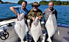
Attracting thousands of fisherman each year, the salmon
capital of the world offers avid anglers excellent saltwater fishing opportunities. The
area surrounding Campbell River is also well known for
its freshwater fishing.
Museum at Campbell River:
Featuring displays of native culture and heritage,
particularly that of the Kwakiutl and Nootka First
Nations, as well as pioneer history. The museum is
located at 470 Island Highway.
Roderick Haig-Brown House &
B & B:
This family home of the famous outdoor writer and
environmentalist, Roderick Haig-Brown who passed away in
1976. His former home is now host to several fly fishing and naturalist events.
Quadra
Island and Cortes Islands:
Both islands offer excellent camping, fishing and hiking
opportunities. Ancient Indian rock carvings and
petroglyphs are found on Quadra Island. Car and
passenger BC Ferries make hourly trips daily
(10 minutes) from downtown Campbell River to Quadra
Island. Ferries to Cortes Island run from Heriot Bay on
Quadra.
The following BC Adventure members would like to serve
you:
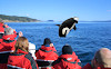
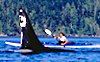
Eagle Wing Whale Watching: Guided Whale Watching Tours & Wildlife Viewing.Trip Advisor's top-rated whale-watching experience in Victoria since 2007. Killer whales, Grey, Minke and Humpback whales, seals, sea lions & porpoise. ... more
Spirit of the West Adventures: We offer sea kayaking tours to the Johnstone Strait & the largest pods of killer whales on the BC coast – Desolation Sound, Quadra Island, & Campbell River - & guided excursions to explore ancient n... more
Hot Pursuit Charters: Guided salmon and halibut fishing charters from Ucluelet, on the West Coast of Vancouver Island. Fish for trophy salmon and halibut. View otters, whales, eagles, sea lions, and bears. more
Rocky Mountain Holidays: Rail Vacations in the Rocky Mountains & Western Canada! Rocky Mountain Holidays customize vacations that combine the romance of train travel with the magnificent scenery of Western Canada. more

 The
Island Highway (Hwy 19) begins in Nanaimo and
The
Island Highway (Hwy 19) begins in Nanaimo and 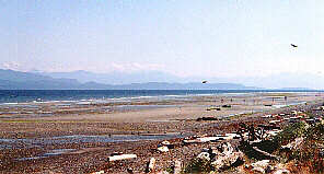 This retirement and
tourist spot is known for good
This retirement and
tourist spot is known for good  Founded
in 1888 by Robert Dunsmuir, this once prosperous coal
mining town offers a glimpse into its historic past
through ancient buildings in the Chinatown area. Other
historic buildings still in use include those housing
the hospital (1894) and the post office (1907). The last
coal mine closed in 1966 and now the town is a peaceful
resort village offering access to the beautiful valley
surrounding. Turn west on the Cumberland road 102 km
(63miles) past Nanaimo. Continuing past Cumberland,
visitors will reach Comox Lake and Lakes Chain. Or
return to Hwy 19 and continue north.
Founded
in 1888 by Robert Dunsmuir, this once prosperous coal
mining town offers a glimpse into its historic past
through ancient buildings in the Chinatown area. Other
historic buildings still in use include those housing
the hospital (1894) and the post office (1907). The last
coal mine closed in 1966 and now the town is a peaceful
resort village offering access to the beautiful valley
surrounding. Turn west on the Cumberland road 102 km
(63miles) past Nanaimo. Continuing past Cumberland,
visitors will reach Comox Lake and Lakes Chain. Or
return to Hwy 19 and continue north.  CFB Comox:
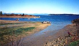 Further north on Hwy 19 is the