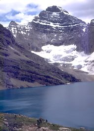
Only one
word describes this National Park and that word is "Yoho,"
meaning magnificent or awesome in the Cree language. Yoho National Park
is in the British Columbia Rockies and filled with spectacular snow peaked
mountains, glacier lakes, streams, and magnificent waterfalls. The Kicking
Horse River portion that makes its way through the park was recently designated,
a Canadian Heritage River.
One of the most important fossil sites in the world, the Burgess Shale,
is also within the park boundary. The site high above the tree line is
about 5 km (3 mi) from the town of Field and in 1980 they named it a UNESCO
World Heritage Site. This 530-million year old site is an ancient sea
bed and contains more than 120 different marine species that are perfectly
preserved. To view the Burgess Shale, take a guided tour, led by a Park
staff member or a licensed guide. Arrange at the Infocentre in Field.
Yoho National Park, bordered by Banff and Kootenay national parks, is
also famous for the vegetation and animal life. The vegetation varies
from west coast cedar, hemlock and devils club, to spruce, pine, alpine
fir and larch, also found within the park are rare and beautiful orchids.
Grizzlies, black bears, mountain goats and many birds inhabit this region.
Outdoor activities in Yoho Park include hiking, mountain biking, fishing
and boating, horseback riding, kayaking, canoeing, and mountain climbing.
Winter outdoor fun means cross country skiing and ice climbing.
Information & Services
If you would like to have your business listed, please Click Here. History:
We know little about Yoho, before 1858, when James Hector explored the
area for the Palliser Expedition (formed to explore western Canada). Archaeological
evidence tells us that aboriginals inhabited this region some 2,500 years
ago, but the research is limited. Yoho Park owes much of the present fame
to the Canadian Pacific Railway and its influence. Surveyed in 1881 by
Major A.B. Rogers, the railway selected Yoho as the route to link east
and west. The first train crossed the continent in the year 1886. For
the next few years a very steep grade known as the Big Hill (on the east
side of Field) created many problems and cost the railway money. To deal
with the runaway and wrecked trains, they constructed many safety switches.
These switches, manned twenty-four hours of every day, diverted trains
onto a runaway track, unless the engineers informed the switchman that
all was under control and to give him the main line. Brakes were checked
at every platform. This practice continued until the year 1909, when they
constructed the Spiral Tunnels, solving the problems of the Big Hill.
The CPR started the tourism trade in this region with the building of
lodges and creating many trails. Yoho National Park has many interconnecting
trails that make backcountry hiking fun and exciting. For a list of the
hiking trails, contact the Infocentre at Field. To stay at the back country
campsites, reservations might be needed, and can be booked through the
Parks Office.
Common Sense and Safety:
When hiking always practice trail etiquette and use common sense. Plan
the trip. Be careful of the environment. Stay on the trails, hike single
file, use a camp stove, stay in designated campsites, pack out all your
garbage and be aware of the wildlife. Safety should be your first concern.
Never attempted a hike that is above your experience and capabilities.
Be safe, have fun.
Emerald
Lake:
Emerald Lake discovered in 1882, is a beautiful green and often seen on
picture postcards. On the shore is Emerald Lake Lodge that the CPR built
and now caters to tourists from all over the world. Make your headquarters
at the lodge and enjoy all the natural wonders of Yoho National Park.
Emerald Lake Circuit:
A short but interesting lakeside hike that the family can take is the
Emerald Lake Circuit. It is only 5 km (3.1 mi.) long and can be easily
done in about an hour and a half. This hiking trail offers a bit of everything,
views of the majestic mountains, the beautiful glacier feed Emerald Lake,
a variety of birds and vegetation. The trailhead at the parking lot at
the end of Emerald Lake Road is also the route for hikes to Burgess Pass,
Yoho Lake and the Emerald Basin. Hike clockwise from the parking lot and
stay on the trail that is closest to the lake. The other trail is for
horse backing riding. Along the trail, signs that provide
information, are an added attraction that helps make this hike extra special.
When hiking on the west side of the lake, look for the many wild orchids,
June and July are the best times to view these rare and splendid flowers.
When reaching the east end of the lake, the vegetation changes to forests
of hemlock, cedar and devil's club.
Yoho Lake from Emerald
Lake:
At the 1.4 km mark on the Emerald Lake Circuit, the trail to Yoho Lake
heads away from the lake going up through a valley. The hike starts as
a gentle hill climb but the steepness increases near Yoho Pass. Looking
back the view includes Emerald Lake and the Van Horne Range. On reaching
the pass, the trail makes its way down to Yoho Lake and an excellent view
of Mt. Wapta. The hike to Yoho Lake is only 8 km (5 mi.) and should only
take about three hours. Nevertheless, it does get a bit steep, so keep
this factor in mind.
Yoho Valley:
The Yoho Valley Road from the Trans Canada Highway goes to Takakkaw Falls,
the most spectacular waterfall in Yoho Park. They plunge straight down
for 254 meters (833 feet) and become part of the Yoho River. There are
five backcountry campgrounds in the region, or camp at Takakkaw Falls
Campground. This walk-in campground with kitchen shelter is a short distance
from the end of the Yoho Valley Road and has thirty-five tent sites.
Twin Falls Trail from Takakkaw Falls:
The trailhead starts from the parking lot at Takakkaw Falls which leads
to the campground and to a large wooden trail map. This trail heads into
a forest of pine and then spruce. At the first large mountain stream,
fill water jugs because it will be a long way to the next drinking water.
After hiking about fifteen to twenty minutes, a trail branches right and
heads to the viewpoint for Angel's Staircase. Just after the junction
is Point Lace Falls. Take time out to view these two natural wonders.
Duchesnay Lake is only another twenty-five minute hike away. The Laughing
Falls Campsite, has eight campsites and a bear pole for food storage.
From Laughing Falls, Little Yoho Valley trail branches left and goes across
the Yoho River. Start climbing until the junction with the Yoho Glacier
Trail that branches to the right. The Twin Falls campsite is only a few
minutes away. It has backcountry campsites and a bear pole. The hike to
Twin Falls and the Chalet is steep, but well worth the efforts. Twin Falls
are very spectacular, as they plunge down the mountain, side by side,
separated by a rocky ridge.
Yoho Glacier Trail:
Continue hiking by taking the Yoho Glacier Trail that starts just before
reaching Twin Falls and the trail to Yoho Glacier. To reach the glacier
is a steep, rough hike and not very exciting. Another option is the Whaleback
Trail from Twin Falls.
Whaleback Trail from Twin Falls:
The trailhead starts just beyond the Chalet, turn left and head up the
group of long switchbacks that lead to the top of the escarpment. Now
the trail makes its way down along the escarpment to the Whaleback campsite
(which could be closed). Beyond the campsite is the trail to Waterfall
Valley, which is a short trail that passes by very interesting scenery,
but they do not maintain the trail. Just above Twin Falls Creek, is a
suspension bridge that leads to the summit of the Whaleback Trail. Be
very careful on the way down the steep switchbacks to reach Little Yoho
River and the junction.
Many other hiking trails are available in Yoho National Park. Get a complete
list at the Infocentre in Field or from the National Parks Branch. When
out hiking always be cautious, use common sense and be on the lookout
for wild animals. Be safe, have fun!
For
more information contact: Yoho National Park Headquarters
Box 99
Field, B.C. V0A 1G0
Phone: (250) 343-6324
Fax: (250) 343-6330

 Only one
word describes this National Park and that word is "Yoho,"
Only one
word describes this National Park and that word is "Yoho,"  History:
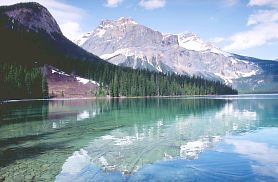 Emerald
Lake:
Emerald
Lake: 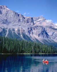 Yoho Lake from Emerald
Lake:
Yoho Lake from Emerald
Lake: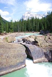 Yoho Glacier Trail: