|
Hiking
the BC Rockies - Columbia Valley

Travel
info
for the BC Rockies. Trails
in this area.
 For
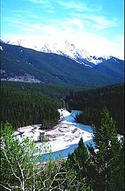
beauty and splendour that's incomparable the Rockies
has it all. This region runs from Revelstoke
east to the Alberta border and south to the US border and down the middle
is the Rocky Mountain Trench. This deep valley separates the Rockies from
the Purcell Range to the west, and making it's winding way through BC
and down into the United States, is the Columbia River. This region is
rich in sheer natural beauty, with alpine lakes, miles of mountain meadows,
rocky peaks and hot springs. Adventures are limitless in the Rockies.
Mountain climb, raft, fish, ski and hike, or just plain relax in one of
the hot springs, drinking in the beauty of the mountains. For
beauty and splendour that's incomparable the Rockies
has it all. This region runs from Revelstoke
east to the Alberta border and south to the US border and down the middle
is the Rocky Mountain Trench. This deep valley separates the Rockies from
the Purcell Range to the west, and making it's winding way through BC
and down into the United States, is the Columbia River. This region is
rich in sheer natural beauty, with alpine lakes, miles of mountain meadows,
rocky peaks and hot springs. Adventures are limitless in the Rockies.
Mountain climb, raft, fish, ski and hike, or just plain relax in one of
the hot springs, drinking in the beauty of the mountains.
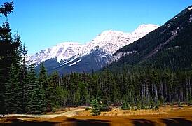
This region
is world famous for it's wildlife.
There are Rocky Mountain grizzlies in the Akamina-Kishinena area, where
they are protected. While the Premier Ridge, has been designated by the
United Nations as the place of the most valuable ungulate populations
outside the Africa's Serengeti Plains. Weather conditions can vary from
place to place in the Rockies, summer are usually hot and dry, the higher
elevation cool quickly. Dress in layers, have rain gear handy, carry spare
water, plenty of sun screen and bug repellent.
Elk
Lakes Provincial Park:
Elk
Lakes Provincial Park with alpine lake scenery offer day hikes and backpacking.
From Elkford on Highway # 43, follow the Westside Road to the Elk River
crossing. Cross the river and follow the Kananaskis Power line road to northeast
park headquarters. The road is rough, 4 by 4's are the recommended vehicles,
there are no facilities as this is a wilderness area so be prepared. The
mountains and glaciers mean good alpine hiking, but be ready for quick weather
changes. Before starting your trip into this region, check at Elkford for
current conditions or contact the BC Parks.
St.
Mary's Alpine Provincial Park:
St. Mary's
Alpine Provincial Park high in the Purcell Mountains is breath taking
alpine splendour in a totally wilderness setting. There are no designated
campsites, and no trails, this is remote back packing country. Hikers
should be experienced and self reliant, definitely skilled with map reading
and know wilderness survival.
Access to
this area is by logging roads, a four-wheel drive is necessary. From Marysville
take the St. Mary's Lake gravel road to St. Mary's Provincial Park and
continue on for another 45 km (28 mi.) north of the park and eventually
you will reach this very remote area.
Kootenay
National Park:
Kootenay
National Park, that borders both Yoho
and Banff National Parks,
has more than 200 km (125 mi.) of trails within it's boundaries. The side
by side position of mountain ranges feature wild open valley that are
super for hiking. Plant
life varies from bunch grass to white rhododendrons, there are more
than 150 species of birds in this area and a wide range of animals that
include bears, mule deer and bighorn sheep. One of the many hikes in Kootenay
is the Rockwall Highline Trail, this is a 3 to 4 day backpack journey
along the base of the Kootenay Wall, which is a 500 metre (1640 foot)
escarpment. Reservations for wilderness campsites should be made well
in advance and can be done by writing. Overnight trips in the Kootenay
require a park-use permit and a user fee, these can be obtained up to
24 hours in advance at park information centres. Camp only is designated
areas.
Mount
Assiniboine Park:
For excellent
and varied hiking conditions, you'll find Mount Assiniboine Park to your
liking. No part of this park lies below 1500 metres (4900 feet) and it has
60 km (38 mi.) of trails that are used all year round, by hikers in the
summer and skiers in the winter. The only other way into Mount Assiniboine
Park is by helicopter. The closest road access is Highway # 93 from Kootenay
National Park and Highway # 1 from Banff
National Park. One of the most popular hikes into the park is from Sunshine
Valley near Banff, Alberta. This trail starts from the Sunshine gondola
to Lake Magog, by Quartzridge, Citadel Pass, Golden Valley and finally Valley
of the Rocks. This is a good 7 to 8 hour hike that's 27 km (17 mi.) long.
There are other hiking spots that are shorter, check them all out.
Bugaboo
Glacier Provincial Park:
The Bugaboos,
a favourite with mountain climbers and heli skiers is also an excellent
place to hike. Bugaboo
Glacier Provincial Park and Alpine Recreation Area, is west of Radium
Hot Springs in the Purcell Mountains. This is wilderness that offers solitude,
masses of spectacular peaks, gorgeous blue lakes and alpine meadows.You
can gain access to the Bugaboos by way of a good gravel road that runs from
Brisco, north of Radium
Hot Springs to the public parking lot. From here it's a steep 5 km.
(3 mi.) hike to Boulder Camp and the Conrad Kain Hut. The user fee accommodations
here are limited to 50 people, so bring your own wilderness camping gear.
There are other trails within the park, for complete hiking information
contact BC Parks.
Yoho
National Park:
Located 30 minutes
east of Golden, on
the Trans Canada Highway,
is Yoho National Park with glacial
lakes, glaciers, waterfalls and mountains. The 400 km. (252 mi.) of trails
makes this a excellent place for the hiker. Along the hiking trails are
waterfalls, some 206 species of birds, fossils, abundant wildlife and beautiful
mountain lakes. Reservations for back country campsites can be made at Field,
the park's headquarters and information centre.
Hamber
Provincial Park:
For extreme
wilderness hiking, hike in or fly into the Hamber Provincial Park, located
north of Glacier National
Park and bordering Alberta's Jasper
National Park. Not only is it the wildest park in B.C. it is also
the most inaccessible. You can hike in, by way of a very difficult 23
km. (14 mi.) trek from Sunwapta Falls in Jasper National Park . To hike
the Sunwapta Canyon to Fortess Lake Trail is a good 8 hours one way and
is only recommended to experienced hikers. Once you reach Fortress Lake
there is limited hiking but the fishing is great.
Good gravel roads off Highway
93/95 south of Canal Flats will take you to three different parks
that truly represent the best the Rockies has to offer. The parks are
Whiteswan Lake, Top of the World and Premier Lake, where the alpine regions
are extraordinary, the fishing is great and the wildlife and flowers abound.
Visiting these three parks means back-country camping and hiking at it's
finest.
|