The
Kettle Valley Railway Trails
British Columbia, Canada
The
Myra Canyon Trestle Resortation Society reports that "All trestles
destroyed by the Mountain Park forest fires of 2003 have been rebuilt
to historical specifications using British Columbia wood and labour."
and that it is now possible to travel over the 12km route between Myra
and Ruth trailheads.
Overview:
The ribbons of steel that made up the Kettle Valley Railway
are gone. All that is left are 16 km (9.9 mi.) of track, the
odd station house and out buildings, a few relics and the history.
The Kettle Valley Railway was the tie that bound the Kootenays
to the rest of British Columbia. The Kettle Valley Railway started
at Hope and went
all the way to Midway, zigzagging
throughout the south western sections of B.C. From Hope, the
KVR made its way through the Coquihalla River gorge. It continued
onward to Princeton, West
Summerland,
Penticton, along the south
side of Okanagan Lake and finally south to Midway, for a total
of 525 km (325 mi.). They constructed branch lines to Merritt
and to Osoyoos, making the
line complete.
Information & Services
If you would like to have your business listed, please Click Here.
History:
In the year 1887, silver ore was discovered in the Kootenays.
Soon American miners were taking over this corner of British
Columbia and the money flowed south of the border. This became
a political issue, which would elect or defeat future provincial
governments. The two remaining railway giants, the Canadian
Pacific Railway, and the Great Northern Railway, an American
railway would be vying for the control of the rail transport
from the Kootenays. Starting in the year 1893 and continuing
for many years, these two feuding railways constructed short
railways connecting towns that were springing up in this region
of B.C. In 1896 the surveying of the Crowsnest Pass started
and the CPR line into the Kootenays was finished in the year
1898. By 1900 the first CPR rolled into Midway. The CPR now
had a railway into the Kootenays from the east, but still no
connection to the west coast.
In 1910 the construction of the Kettle Valley Railway started.
The hardships were many, and construction costs were high. Andrew
McCullogh was the chief engineer and nothing would stand in
his way of completing this railway. Against all the hardships,
the Kettle Valley Railway was finished on July 31, 1916. For
the first time there was daily passenger and freight service
from Vancouver to Nelson. The KVR started its downward slide
in 1949 when Highway # 3 (the Hope Princeton) opened. During
the next few years, obviously to keep the KVR running was no
longer feasible. In 1962 they removed the Coquihalla section
of tracks. In January of 1964 the last passenger train ran from
Merritt to Penticton and onto Midway and finally Nelson.
The Kettle Valley Railway was closed.
Stations along the KVR:
Andrew McCulloch, was not only a brilliant engineer but he had
a real passion for Shakespeare, and the stations along the Coquihalla
section were named after characters from his plays. Station
names such as Juliet, Romeo, Lear and Othello are found between
Hope and Brodie. From Brookmere to Princeton stations and interesting
hiking came be found at Spearing, Thalia, Manning, Tulameen,
and Coalmont. The next section of the KVR is from Princeton
to Penticton with sites such as Belfort, Erris, Osprey Lake,
Thirsk, West Summerland and Winslow. Penticton to Midway, the
last section includes stops like Chute Lake, Ruth, Myra, McCulloch,
Lakevale, Breaverdell, Westbridge, Rock Creek and finally the
end of the line.
Hiking
the Kettle Valley Railway:
The only remaining track is a section 16 km (9.9 mi.) long found
west of Penticton, but people are returning to the KVR. People
hike, mountain bike, four by four and horseback along the rail
bed and the Kettle Valley Railway is making a comeback.
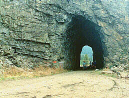
Othello and the Quintette Tunnels:
Just a few miles east of Hope is Othello where the Quintette
tunnels are part of an official park with entrances from both
the north and south. To reach the tunnels from the north end,
take the Kawkawa Lake Road from Hope and go east about four
miles, watch for the Quintette Tunnels sign. Park and walk the
rest of the way to the tunnels. To reach the south entrance,
walk the old KVR right of way. Take the Kawkawa Lake Road to
the cemetery, turn right and make your way to the intersection
of gravel roads. Park your vehicle and hike to the tunnels.
The hike into the Quintette is an easy trek that the whole family
can enjoy.
Hope to Brodie Station:
From Hope to Brodie the Coquihalla Highway makes its way along
much of the same route as the KVR. In some spots one can see
the old rail bed and sometimes even hike into these sites. The
information sign at Coquihalla Lakes offers a short history
about the Coquihalla pass that ranchers used for cattle drives
as early as 1875. At the Coldwater River crossing is a picnic
site, and near the iron bridge the information sign tells about
the work that Chief Engineer, Andrew McCulloch, accomplished.
Brookmere to Penticton:
Brookmere was once a divisional point for both the KVR and the
VV & E ( part of the American Great Northern). Both railroads
build a round house and a turntable. Both shared the water tower
and the station house. The water tower still stands. Some KVR
rail remains and the GN station house is a private home.
Coal from the Tulameen Valley was used to run locomotives on
both railways. The once thriving and booming coal town of Tulameen
is now a ghost town and the KVR station house is now a private
home. Coalmont, south of Tulameen, is still another town from
the past. The Coalmont Hotel and a few false front buildings
are all that are left. Next is Princeton, where a loop of track
that served as a train turnaround and a tunnel are all that
remain of the KVR. An old CPR caboose serves as a tourist information
centre in Princeton, giving us a glimpse into the past.
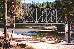
Trout Creek Bridge:
The section of the KVR that once ran from Princeton to Penticton,
also made its way into the Okanagan Valley. The most interesting
site along this section of railway is the Trout Creek Bridge,
the highest bridge on the KVR. Located west of Summerland the
span is 188 meters (616.6 ft.) long and 73 meters (235.4 ft.)
high. View this bridge is from the Agricultural Research Station
at Summerland, just off Highway 97 near Sunoka Beach. For your
protection there is a chain-link fence that guards the edge
of this awesome canyon.
Penticton was the KVR Headquarters where they built repair and
service facilities. In October 1912, the first locomotive arrived
in town and everyone celebrated. In 1915, when the line was
finished from Merritt through to Midway, they held another celebration
when the first passenger trains came in from both the east and
west. The Penticton station is no longer in use, and the KVR
right-of-way are now footpaths across the city squares.
From Penticton to Midway:
The Kettle Valley Railway from Penticton made its way to Naramata,
and onto Arawana. A couple of roads offer good access to the
railway line for the many people who like to walk this section.
Next stop was the Glenfir station, which is approximately nine
km (5.5 mi.) north of Penticton. Not far from Glenfir is Rockovens
Park and an old growth stand of pine trees. A marked trail leads
to the site of the one and only surviving oven that they make
from stones. This is a steep climb. At Adra, walk through the
long tunnel or bypass it by climbing up through Rockovens Park,
where there are magnificent views of Okanagan Lake. A good place
for a base camp is Chute Lake, from here your can hike both
directions and enjoy the few relics that remain of the Kettle
Valley Railway.
Myra Canyon:
Myra Canyon is spectacular. Sixteen trestle bridges cross along
this13 km ( 8 mi.) stretch of railroad. This is an ideal hike,
especially in the spring or fall. This section of the KVR is
the best example of railway construction of the early twentieth
century. The trestles have been rebuilt to historical specifications
using British Columbia wood and labour after a wildfire destroyed
the original structures in 2003.
To
access Myra Canyon by vehicle, take KLO Road to McCulloch Road,
follow McCulloch Road past Gallaghers Canyon Golf Course, until
you reach Myra Forest Service Road. It is marked with signs.
Follow that road 8 � kms to the rail bed and the Myra parking
area. Avid cyclists may wish to access from the June Springs
entrance on the west side of the Canyon.
For
more information and maps
of Myra Canyon visit the excellent website of the Myra Canyon
Tretle Restoration Society at www.myratrestles.com
From McCulloch
station the KVR curves south, this section is good hiking, but be careful
of the many washouts. Cookson, is marked by a red freight shed. The Lakevale
station site is now a Forestry camp site. Between the stations of Lakevale
and Lois is a hiking or 4 by 4 trail. The only thing surviving at Lois
is a red freight shed. Carmi was once a booming town with a gold mine,
a jail, a hospital, two hotels, two stores and gas stations. It is now
a ghost town. In Beaverdell is an old hotel (the oldest in B.C. is the
claim) where outside stands a KVR railway signal. At Rock Creek, the KVR,
now a road, runs through the centre of the village.
Midway
is the half way point across British Columbia and where the Kettle Valley
Railway joined the Canadian Pacific Railway that continued to Alberta
and onto eastern Canada. The museum at Midway has a CPR caboose and a
section of track. KVR right of way is found under the highway bridge and
follows the Kettle Valley River as it makes its way to the U.S.
The Kettle Valley Railway is now just part of history. With more people
finding time for outdoor fun and enjoyment, it seems only natural that
the old KVR railbed is becoming very popular with hikers, mountain bikers,
and horseback riders. Now only parts of the KVR are open to the public,
but interested parties are working on making the full railway available
for recreational use. No matter where hiking in British Columbia be safe,
have fun!

 Hiking
the Kettle Valley Railway:
Hiking
the Kettle Valley Railway: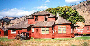 Midway
is the half way point across British Columbia and where the Kettle Valley
Railway joined the Canadian Pacific Railway that continued to Alberta
and onto eastern Canada. The museum at Midway has a CPR caboose and a
section of track. KVR right of way is found under the highway bridge and
follows the Kettle Valley River as it makes its way to the U.S.
Midway
is the half way point across British Columbia and where the Kettle Valley
Railway joined the Canadian Pacific Railway that continued to Alberta
and onto eastern Canada. The museum at Midway has a CPR caboose and a
section of track. KVR right of way is found under the highway bridge and
follows the Kettle Valley River as it makes its way to the U.S.