Location:
From Kamloops
take the Yellowhead Hwy #5 north to Little
Fort. At Little Fort, turn west (left) on Hwy 24. Continue
to Sheridan Lake and the junction
of Hwy 24 and the road to Horse Lake
(about 65 km/40.3 miles). Turn north and proceed on the Horse lake
road for 4.6 km (2.9 miles) to the junction of Mahood Lake road
and Canim Lake S. road. From here travel for another l5.05 km (9.3
miles) to the junction of a road (on your right) which accesses
the recreational cabins and a resort on the south side of Mahood
lake. From the junction of Mahood lake road and the road leading
to the south side of the lake, continue on Mahood lake road for
an additional .65 km (.4 miles) to the boat launch and provincial
campsite. To access the lake from 100
Mile House, follow the Horse Lake Road east to the junction
of the Mahood Lake road and the Canim Lake S. road. From there,
proceed as described above.
Resorts
& Campsites:
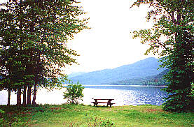
A beautiful BC provincial park is located at the west end of the
lake. Mahood Lake Provincial Park has a campground with 34 sites,
offering communal pit toilets, firewood, and cold running water.
Camping fees apply. The park also features a day use picnic area,
large sandy beach with excellent swimming, a play area and a large
playfield. Also there are many beaches with flat rocks ideal for
skipping.
BC Adventure Network members serving this area:
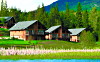
Alpine Meadows Resort: Our luxury outdoor destination is located on Hallamore Lake in BC’s spectacular North Thompson. We feature deluxe chalets & spacious log homes. Experience adventure and serenity, in a natural setting with pure air, sparkling waters and magnificent views. more
If you would like to have your business listed, please Click Here.
Fishing
Report: Trolling is the best method for large wild rainbows,up
to l0lbs, and lake char that reach 20lbs. or better. At the mouths
of creeks feeding into the lake, spinning gear and flies net excellent
results. Mahood River, a small stream located at the west end of
the lake can be very good using stone fly imitations and other Mahood
is a very large lake and can at times become very windy. Caution
should be used if you are using small boats.
Be
sure to visit Fishbc.com
for angling information!
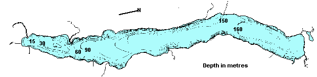
Viewscape:
Mahood lake is located in a U-shaped valley between the Quesnel
Highlands to the north and the Shuswap Highland to the south. The
surrounding terrain to the north and south of the lake rises very
sharply to an elevation of 70m (230 ft.) to the start of a flat
lava plateau of pleistocene basalts. The west end of the lake rises
gradually up the Canim river valley to Canim lake, some 6.5 km.
(4 miles) away and approximately l43 m (469 ft.) in elevation above
the level of Mahood lake. The terrain surrounding Mahood lake is
mostly coniferous forest consisting of cedar, hemlock, engleman,spruce
and subalpine fir.
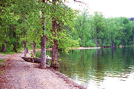
Shoreline:
Steep shoreline composed mainly of boulders of volcanic origin.
Many basalt rock bluffs are found around the lake shore. Access
is by boat only (except for the provincial park beach which is mainly
sand). These beaches are great swimming, waterskiing and tenting
areas.
Nearby
Lakes
There
are literally hundreds of great fishing lakes nearby.
Note:Always check your current BC Fishing regulations before you start
fishing a new lake.