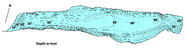
BC's On-Line  Hotel  Reservation System
Contents   Cariboo Chilcotin Coast

Google

Cariboo Chilcotin Coast
Lodging & Services
Recreation
Cities & Towns
Lakes

Travel Info
Points of Interest
Provincial Parks
Trails

Visit BC
Cariboo Chilcotin Coast
Northern BC
Rockies Kootenays
Thompson Okanagan
Vancouver & Coast
Vancouver Island

City Guides
BC Communities
BC Vacations
Fishing Vacations
Western Vacations
Eco-Adventures
Storm Watching
Ski Vacations

Golf Vacations
RV Vacations
Houseboat Vacations
Outdoor Adventures
Camping Expeditions
Guides & Outfitters
Guided Tours
Charters
Attractions
Events
Lodging
Search Lodgings
Hotels, Motels & B&Bs
Suites, Rentals & Condos
Wilderness Resorts
Saltwater Resorts
Guest Ranches
Health Spas, Hot Springs
Golf & Ski Resorts

Campgrounds & RV Parks
Add a Listing
Recreation
Search by Activity
Attractions

ATV
Boating
Camping
Canoe & Kayak
Dog Sledding
Fishing
Golf
Horseback Riding
Guided Tours
Health/Spas
Cat & Heli-Skiing
Hiking
House Boating
Mtn. Biking
Mtn. Climbing
Hot Springs
River Rafting

Scuba Diving
Skiing
Snowmobiling
Whale Watching
Fish BC
Saltwater Fishing
Lake Fishing
River Fishing
Fishing Vacations
Fishing Suppliers
BC Game Fish
Trophy Destinations
BC Fly Patterns
Entomology
Tips & Techniques
Travel Routes
Circle Tours
Maps
Points of Interest
Travel Logs
Brochure Rack
Browse
Trip Planner
Plan Your Vacation
Tourist Info

Special Events
 Road Reports
 Weather Reports
 Mileage Calculator
Coastal Ferry Info
Vancouver Airport
Transportation
BC Quick Facts
Customs
Currency
Taxes
Medical
Metric System
Motor Vehicles
Time Zones
Area Codes

Outdoors
Animals
Birds
Fish
Wildflowers
Trees
Survival
Parks
Trails

Wines of BC
BC Wines
Wineries
Wine Tours


www.bcadventure.com
Konni Lake
Click on the lake icon at the right to see full bathymetric map.
Click on the moose on the left for complete BC travel information.


Location:
At Williams Lake turn west on Hwy 20. Continue approx. 97 km (60 mi) to Hanceville (a.k.a. Lee's Corner). Turn south off Hwy 20. Travel 4.67 km (2.9 mi), crossing the bridge over the Chilcotin River. Take the Taseko Lake Road and follow it for about 85 km (52.7 mi). Then take the Big Lake/Konni Lake Road and follow it for another 23 km (14.26 mi) to Konni Lake.

Size 565.37 ha (1,396 acres) Shoal Data not Available
Mean Depth 17.2 metres (56 ft) Max. Depth 29.87 metres (98 ft)
Game Fish Rainbow Fish Stocked None
Angler Usage Low Elevation 1213 metres (3,978 ft)
Ice Over November - May T.D.S. 422 mg/L

Resorts & Campsites: No resorts and no organized campsites at the lake, but the Chilko Lake BCFS campground is just a few miles down the road. It is an 8 vehicle camp with picture postcard views of Chilko Lake and the Coast Mountains.

Fishing Report: Wild Rainbows average 1½ lbs with some up to 5 lbs or better. Trolling is the preferred method, however, spinning gear and fly fishermen also take their share. Fishing remains good from May through October. Boaters should be aware that strong winds are common in this area.
Be sure to visit Fishbc.com for angling information!

Viewscape: Very mountainous. The north side of the lakes has bare slopes, with some Douglas Fir. The south side of the lake is heavily forested with spruce and pine.

Shoreline: Consists of large boulders with alders.

Nearby Lakes

Fish Lake - Situated about 16 km (9.92 mi) southeast of the Taseko River bridge, this small lake is an excellent producer of small wild stock rainbows. Considered a good starter lake for children. Kids won't get bored for lack of fish. There is a small BCFS campsite with a great view of Anvil Mountain. Cartoppers and canoes can be launched from this site.

Note: Always check your current BC Fishing regulations before you start fishing a new lake.


Global Marketing Specialists

Advertise With Us

Promote your business to over 5.5 million BC visitors per year.
A
dvertise on the BC Adventure Network, British Columbia's largest and most visited tourism Web site . . . more info.


© 1995 - 2008 Interactive Broadcasting Corporation