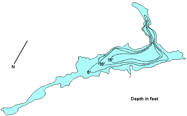
BC's On-Line  Hotel  Reservation System
Contents   Cariboo Chilcotin Coast

Cariboo Chilcotin Coast
Lodging & Services
Recreation
Cities & Towns
Lakes

Travel Info
Points of Interest
Provincial Parks
Trails

Visit BC
Cariboo Chilcotin Coast
Northern BC
Rockies Kootenays
Thompson Okanagan
Vancouver & Coast
Vancouver Island

City Guides
BC Communities
BC Vacations
Fishing Vacations
Western Vacations
Eco-Adventures
Storm Watching
Ski Vacations

Golf Vacations
RV Vacations
Houseboat Vacations
Outdoor Adventures
Camping Expeditions
Guides & Outfitters
Guided Tours
Charters
Attractions
Events
Lodging
Search Lodgings
Hotels, Motels & B&Bs
Suites, Rentals & Condos
Wilderness Resorts
Saltwater Resorts
Guest Ranches
Health Spas, Hot Springs
Golf & Ski Resorts

Campgrounds & RV Parks
Add a Listing
Recreation
Search by Activity
Attractions

ATV
Bear Watching
Boating
Camping
Canoe & Kayak
Dog Sledding
Fishing
Golf
Horseback Riding
Guided Tours
Health/Spas
Cat & Heli-Skiing
Hiking
House Boating
Mtn. Biking
Mtn. Climbing
Hot Springs
River Rafting

Scuba Diving
Skiing
Snowmobiling
Whale Watching
Fish BC
Saltwater Fishing
Lake Fishing
River Fishing
Fishing Vacations
Fishing Suppliers
BC Game Fish
Trophy Destinations
BC Fly Patterns
Entomology
Tips & Techniques
Travel Routes
Circle Tours
Maps
Points of Interest
Travel Logs
Brochure Rack
Browse
Trip Planner
Plan Your Vacation
Tourist Info

Special Events
 Road Reports
 Weather Reports
 Mileage Calculator
Coastal Ferry Info
Vancouver Airport
Transportation
BC Quick Facts
Customs
Currency
Taxes
Medical
Metric System
Motor Vehicles
Time Zones
Area Codes

Outdoors
Animals
Birds
Fish
Wildflowers
Trees
Survival
Parks
Trails

Wines of BC
BC Wines
Wineries
Wine Tours


www.bcadventure.com
Beaver Lake
Click on the lake icon at the right to see full bathymetric map.
Click on the moose on the left for complete BC travel information.


Location:
At Williams Lake turn west onto Hwy 20. About 21 km (13 mi) west of Riske Creek turn north off Hwy 20 onto the Palmer Lake Forest Access Rd. Travel this road for about 42 km (26 mi) and then turn north off the Palmer Lk Rd and travel about 10 km (6.2 mi) to the lake. This last 10 km is very rough and it gets worse in wet weather. 4x4's are advisable.

Size 259 ha. (640 ac.) Shoal Data not available
Mean Depth 2.1 m. (6.9 ft.) Max. Depth 6 m.(20 ft.)
Game Fish Rainbow Trout Fish Stocked None
Angler Usage Moderate Elevation 1,195 m.(3,919 ft.)
Ice Over November - Late April T.D.S. 300 mg/L

Resorts & Campsites: There are no resorts or organized campsites on Beaver Lake, but there are 2 areas suitable for camping. One area is located at the w.s.w. end near the outlet, and the other area is located at the n.w. inlet. Cartoppers can be launched.

These BC Adventure Network members invite you to stay/adventure with them:

If you would like to have your business listed, please Click Here.

Fishing Report: Beaver is a very shallow lake, so during the hot summer months fishing can drop off. However, early and late season fishing can be excellent. Lots of large rainbows are the order of the day.
Be sure to visit Fishbc.com for angling information!

Viewscape: Beaver is surrounded by rolling hills covered in Pine forest.

Shoreline: Consists of grass, deciduous shrub and pine trees.

Nearby Lakes

Stum Lake (aka Pelican Lake) - Just past Beaver Lake on the left hand side of the road is Stum Lake and White Pelican Park. An interesting lake because it is the summer home of a colony of White Pelicans. Fishing is prohibited from March 1st to August 31st.

Note: Always check your current BC Fishing regulations before you start fishing a new lake.


Global Marketing Specialists

Advertise With Us

Promote your business to over 5.5 million BC visitors per year.
A
dvertise on the BC Adventure Network, British Columbia's largest and most visited tourism Web site . . . more info.


© 1995 - 2009 Interactive Broadcasting Corporation