Article reprinted by kind permission
of RVers On-Line
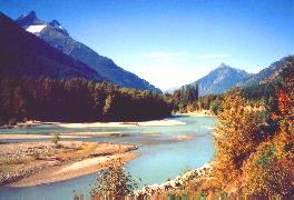
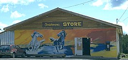
The ferry terminal is located at the end of a long fjord (North Bentinck Arm). The village of Bella Coola is some three kilometers up the Bella Coola river valley. In that three kilometers we saw easily a hundred bald eagles, seasonally attracted to the area by the spawning salmon. We didn't know what services would be available at Bella Coola. But we quickly found that it has an excellent full-service supermarket and hardware store, where the visitor can buy just about anything one might want. Since the trip from Port Hardy is done with propane tanks closed and sealed (no refrigerator), Bella Coola is an obvious choice for stocking the refrigerator for the next several days' exploring. For the first night's stay we settled on the Gnome's Home RV Park in Hagensborg, a small colorful Norwegian village located ten miles east of Bella Coola. The owner/manager, Karl Osmers, was most helpful in pointing out many of the "must see" places in the Bella Coola valley. His RV park, offering 40 full service sites on 20 acres, provides its own private area to explore -- a large chunk of old growth timber, enlivened by small creeks (complete with spawning salmon during our visit), and all made accessible by a carefully laid trail comprised of 4" x 12" timbers which wander through this pristine forest. We'd heard much about the large population of "urses americanus" (black bear) and "urses horribilis" (grizzly bear) in the Bella Coola valley. Here we could see the trails they'd carved through this old growth rainforest "jungle". We'd interject a note for the satellite TV aficionados. DirecTV disclaims any coverage in Canada, as it apparently has no license there. Accordingly, it does not provide any information about just how far north into Canada its coverage extends; nor does it provide information on the elevation and azimuth to catch the signal. We found it with a little trial and error at 24.5 degrees elevation, and 128 degrees on the compass, with a signal strength of 76.. We found Gnomes Home a most pleasant base camp for exploring the Bella Coola valley. Unfortunately, it seems all too many travelers disembark the ferry at Bella Coola, and don't slow down until they've driven through the Bella Coola valley and topped "The Hill" (see below), the 11 miles of grade which challenge vehicle and driver alike. Unfortunately for these visitors, they've just sped by some of the most fantastic opportunities and scenery available anywhere in the world. The valley is bordered by high granite cliffs, rising nearly 10,000 feet, and more than rivaling the vistas in Yosemite National Park. Much better vistas -- and almost no people! The extensive river system traversing the valley, some glacial in color, host some of the largest salmon and steelhead runs on the planet. Government campgrounds in Tweedsmuir Provincial Park -- the largest in BC -- offer well maintained (no service) primitive sites in a pristine forest environment, with a never ending view in all directions. The small but elegant Tweedsmuir Lodge is a "must see" -- if only to check out the incomparable view from its flower laden front deck. Jutta (pronounced "Uta") is the very gracious innkeeper. Of German descent, and a resident in winter months of Vancouver Island, she maintains this small 7 room lodge and 2 cabins, and is a delightful hostess for visitors. With beautiful internal furnishings, the lodge seemed to us a miniature equivalent of the famed elegant Ahwanee Lodge in Yosemite. But again -- without traffic, noise, or any obvious sign of crowds. This seemed to us the ultimate in peace and quiet... Once we'd passed the second campground in Tweedsmuir, some 50 miles from where we'd landed at the ferry terminal, we shortly found ourselves looking up -- almost straight up it seemed. The road had now lost its paved surface and headed up the grade which will be remembered by all who visit here -- "The Hill". But read on...
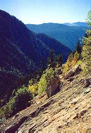
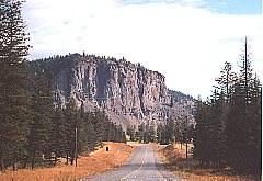
'The Hill' is the without question the most talked about segment of Highway 20, the roadway which connects Bella Coola on BC's mid-coast and William Lake on the Alaska Highway. Because of its steepness, it no doubt discourages many travelers, particularly RVers, from coming this way. We researched "The Hill" using a variety of sources before we made the journey -- but we did not find any objective first hand account of just what to expect. Since we've now driven The Hill both from the bottom up and from the top down, we want to set forth our experience and impressions for those who plan a trip through this utterly fantastic country. With hindsight we think most of the "fear" here may well be of the "unknown". Let's start at the bottom of the hill. We'll document each segment of this 11.2 mile climb (starting at approximately 1,000 ft) to the top of Heckman Pass (elevation approximately 5,000 ft). Going east from Bella Coola, the pavement ends exactly where "The Hill" begins its ascent. The surface here is gravel, but seal coated to keep the dust down. The grade quickly ascends 2.1 miles to the lower of two spacious "switchbacks". The climb was both steep and steady, but using second gear we were using only a fraction of our available power. This segment appeared to us to be the steepest part of The Hill, and it landed us at the first switchback -- an extremely wide turnout with lots of level parking area to stop and enjoy the changing views. Between the first and second (last) switchback is a mere 1.1 miles. The grade here, while still persistently steep, appears to be on average a couple of degrees less than the bottom (2.1 mile) segment. Along this stretch there is a bit of a vertical overhang along the right side of the roadway going up. This presents no problem to commercial trucks and RVs, which can avoid the overhang by moving a bit to the left of the center of the road. But the roadway here is clearly "one lane" at this point of passage. As a practical matter this doesn't present a problem for vehicles either ascending or descending the grade, as there are ample pull outs both above and below this somewhat constricted portion of the road. The driver of an overheight vehicle simply needs to be aware of this slight obstacle, and be prepared to use one of the turnouts if a vehicle is approaching this point from the opposite direction. While the second switchback is not quite as spacious or level as the first, it still offers a point to pause and check the vistas here if desired. The next 3.4 miles will take you to the top of the "main" portion of The Hill. The first 1.3 miles rivals the bottom segment in grade, but thereafter the grade eases somewhat for the next .8 mile, and moderates to a very ho-hum climb for the last 1.0 mile to what initially appears to be the summit.
While Heckman Pass is still 5.2 miles ahead, and some 1,000 vertical feet higher, at this point most of the challenging portion of The Hill is now behind you. From here the road dips down a few hundred feet over the next 1.8 miles before resuming its final climb to the top of Heckman Pass. This last 3.4 mile segment climbs approximately 1500 feet to the top of the pass. The overall average grade here is noticeably less, though portions of the last mile offer a few reasonably sharp turns, and shorter grades comparable to some of the steeper parts you've already encountered. But there are no cliffs or overhangs along this portion, and by comparison this segment is "duck soup". With this detailed description in mind, we'd like to offer some of our own impressions from doing The Hill in both directions. First, we should point out that the vehicle we were driving was ideally suited for this type of roadway. We were driving a one ton Dodge dually, equipped with four wheel drive, a five speed transmission, and a Pac Brake which provides the diesel engine with considerably more compression than diesel engines typically offer. In the truck bed was an 11 foot slide in camper unit which weighs in at just over 3,000 pounds. We used second gear going up the hill, and engaged the four wheel drive simply for added convenience -- we clearly didn't need it. Ascending in second gear left a great deal of power unused. In fact, at no time did the auxiliary cooling fan even come on. Descending The Hill we used second gear on the steepest sections, and third gear on the rest. And with the benefit of the Pac Brake, we could have done the entire downhill run without touching the service brakes had we wanted to do so. We do not want to either understate or overstate our evaluation of the relative difficulty of The Hill. To us, it was considerably less challenging than we had expected -- in both directions. At the relatively slow speeds most drivers will handle this road, it is not particularly bumpy for a gravel road. The main portion of the hill is mostly a two lane road for the top portion, changing to a mostly one lane road with ample pullouts to permit passing on the lower portions. The middle segment -- that portion between the two switchbacks -- offers a fairly steep downhill drop off at the outside edge of the road, but we found it somewhat less intimidating in that respect than other back roads we've traveled on other occasions. Traffic is quite light, and is comprised of everything from an occasional biker to 18 wheelers. There is a bus service twice weekly between Williams Lake and Bella Coola which travels this route as well. While we found both the uphill trip and the downhill trip quite easy (with hindsight Stephanie now says she'd be comfortable driving it either way -- and would far prefer either to driving through Los Angeles on the freeways), most travelers would probably find the uphill trip the easier of the two. For vehicles towing fifth wheels or travel trailers, we'd think the trailer brakes and brake controllers should be carefully tested before attempting the downhill run to ensure both braking systems were contributing their fair share. And of course the challenge of The Hill increases proportionately with the gross combined vehicle weight. We recognize that any type of mountain driving will be viewed differently by drivers familiar with mountainous terrain, than by those whose experience has been limited to the flatlands. We think that by simply observing some common sense considerations, driving The Hill can be an entirely pleasant trip in either direction. Go in daylight hours when visibility is not impaired (the vistas are wonderful), and avoid treacherous weather conditions. Above all, take your time. Drive slowly using lower gears, and make a few stops along the way. The locals will advise stopping a few times on the descent to let your brakes cool. We hope these observations will be helpful to those considering making
the fabulous trip between Williams Lake and Bella Coola. And while we
recognize The Hill as probably not suitable for the "quite faint at
heart", we suspect most will find that its challenge is somewhat less
than what they had expected. And armed with the information which we've
provided above, we think RVers and others will have much more information
about the characteristics of The Hill than they've had before -- which
we hope they'll find helpful.
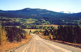
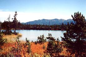
Heckman Pass to Anahim Lake. By the time one reaches the top of the pass, the terrain begins to look quite different. Gone are the old growth cedar, spruce and fir. In their place, an alpine setting of smaller lodgepole pines, and sweeping vistas into the colorful, rocky slopes of the Rainbow Range. Just past the summit a trailhead invites hikers for a closer look, with trails ranging from one to 21 days -- some involving significant changes of elevation. Here, as everywhere, one finds warnings about bears (Black Bears & Grizzly Bears live here) -- they can be anywhere, anytime. But be particularly watchful in avalanches, berry patches, and along stream beds -- particularly where one may find spawning salmon. The road here, still gravel, is in places a bit rougher than that encountered on the hill. In places it has been oiled to keep the dust down. But vehicles are few and far between, providing a feeling of being somewhere in a vast, last wilderness. Small lakes dot the landscape, and small creeks criss-cross the wandering roadway. You're now in an area which still belongs to the wildlife -- bear, deer, moose, wolves, cats (not kitties!). One has a feeling of being a visitor to one of the last wilderness area which they still claim as their own.
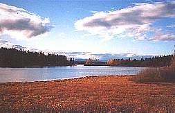
Some 30 miles beyond Heckman pass is the first sign of civilization -- Anahim Lake. Here you'll find a small community with a partly native population, including a gas station, a few small stores, and a pleasant Dutch restaurant. The attraction is the lake itself. And what a lake it is. There are no float planes here. The sounds that are most frequently heard are those of the loons and eagles. Bird watchers will find a wide variety of waterfowl on the lake, including (seasonally) white pelicans and trumpeter swans. This may well be the most productive lake for anglers, in terms of numbers (if not size) of wild rainbow trout of any lake easily accessible by car or RV. We had occasion to stay at both RV "resorts" on the lake -- Escott Bay Resort and Anahim Lake Resort. Both offer what we considered very reasonably priced RV sites with hookups, and had cabins for those arriving by car. While an occasional RV caravan can cause a crowd in these parts (most RV parks along this segment have fewer than 20 sites), usually there's more than enough room to spread out. We were now in country which made us wish we'd brought along a small boat of some type, since fishing was best from the water. However, most resorts, including these, offer boats and motors, or canoes, for hourly or daily rental. Since most visitors come in from Williams Lake, rather than up from Bella Coola, Anahim Lake is the most distant destination for most travelers. We think it would be an excellent choice not only for exploring Anahim Lake, but also as a "base camp" for exploring by car or truck some of the surrounding lakes in the area -- many of which are accessible via roads of varying quality, and most of which offer no services or camping facilities. Here, once again, a small boat of some type would be a wonderful aid in exploring more of this pristine wilderness area. Supplies, while a bit limited, were better than we'd expected at the
primary grocery store in Anahim Lake. Some fresh meats and poultry were
available, as were a fair selection of produce. Staples, camping supplies
and fishing gear were all available as well.
This is a very short distance, but since it's still in the heart of some of the most beautiful and unspoiled area of the Chilcotin, it deserves separate mention. One notable feature of this 12 miles stretch is pavement. Yup, the same kind we drive around on at home. And it extends a few miles south of Nimpo Lake before returning to its now familiar gravelly self. But let's not make the mistake of passing up Nimpo Lake, because there's much to explore here as well. Those of us who have been lured into one of those annual "outdoor sports shows" will have a vague recollection of the name -- "Nimpo Lake". That's because some of the major "fly in fishing" operations are based here. Their representatives are frequent participants at these sports shows, offering brochures showing wilderness scenes filled with all types of wildlife and trophy sized fish. The seaplane base that supports these fly-out operations is right here in the tiny community of Nimpo Lake. But many in British Columbia prize Nimpo lake not as a place to fly away from, but rather as a choice RV destination.
We decided to do some exploring on our own, and visited a sampling of those resorts which also offered RV accommodations. The place we chose to stay is Pine Point Resort, which is not in or near the village which accommodates most of the resorts and the seaplane operation; but rather is on a gravel access road which intersects Highway 20 about 4-5 kilometers south of town. A ten minute drive lands you at the resort, where you'll spot a number of attractive RV sites, mostly partly or fully serviced, some very attractive log cabins, and a dock with a number of rental boats. Chances are good the person who will greet you is Rod Thatcher, the owner/manager. This resort caters to three "categories" of guests -- and they appear to do a wonderful job accommodating each. One is the group of RVers who are simply looking for a nice site with hookups, and access to a lake with an excellent reputation for producing good size native rainbows. Typically these folks have brought along their own small boat or canoe, and they're here to enjoy Nimpo lake. The second group are those arriving by car, and who want to rent a housekeeping cabin by the week. These folks too usually bring along some sort of small boat. And, finally, the "fly out" group. These are the avid fishermen who book packages ranging from 3-7 days, which include daily fly-out fishing to any number of lakes generally within 60 miles, and which are accessible only by float plane. The package for this group includes everything -- all meals, licenses, daily fly-in to lakes of the client's choosing, and unlimited use of the rental boats which the resort maintains on Nimpo Lake. In short, there's something here for everyone. We've seen a great deal
of advertising for fly-in fishing adventures. These packages are not
inexpensive, and we suspect some must be much better than others. Based
on our own observations, we were extremely impressed with the integrity
and professionalism of both Rod Thather and his staff. If we were ever
to book a fly-in package, I'd have a great deal of confidence that we'd
be getting the full measure of what we were paying for. In our view,
it's a class act..
The choices of places to visit along this 118 mile segment seem endless. Just south of Nimpo Lake the pavement ends once again, and the gravel road here varies from seal coated to dusty. But this is the last of the gravel road, as a few miles north of Tatla Lake (some 48 miles south of Nimpo Lake) paved road returns for good -- at least until you turn off to follow a gravel road to some other lake in the Chilcotin. Near Tatla Lake we pondered a side trip south some 60+ kilometers to Chilko Lake. Many with whom we'd spoken along our route had recommended this area for its unique and pristine beauty. By now we'd begun to wonder whether anything could top the scenery we'd already encountered. Suffice it to say that we opted to continue on another 45 minutes to the turnoff to Puntzi Lake, which is located some 6 kilometers north of Highway 20 -- of course on a gravel access road.
Puntzi Lake is also known for its fishing -- both rainbow and kokanee. Like many lakes in this area, fishing is best during the late spring and early summer months. It tends to slow down considerably during the hotter weeks of July and August; and then resumes again as cooler temperatures return. We found 5 attractive RV resort "candidates" at Puntzi Lake, and somewhat on a whim choose the Puntzi Lake RV Resort. We were extremely pleased with our choice, as this RV park offered well landscaped sites, all nicely maintained and most with full services. The sites along the lakeshore were particularly attractive, though some set back into the woods bordered on a huge, well mowed meadow of lawn. Missy, our somewhat spoiled Britanny, appreciated the chance to race around in this vast well manicured meadow. The next morning would bring us a surprise we hadn't yet even imagined. Once we returned to Highway 20, we joked a bit about whether we should turn left, and continue our planned route through Williams Lake and complete the loop home by taking the Alaska Highway south -- or whether we should turn right, and go back for a "second helping" of the wondrous Chilcotin countryside we were leaving behind. For the moment at least, discipline kept us heading east towards Alexis Creek. But the nagging feeling persisted: Were we really going in the direction we wanted to? Then somewhere near Alexis Creek we saw a prophetic sign. It said "Passing Lane Ahead". What? A "passing lane"? Were we really getting back to places where there were that many cars? Where there was "traffic"?
We entered Alexis Creek and found the pay phone located outside of the general store.. A toll free call to BC Ferries conveyed our request to book passage to go back the same way we'd come -- i.e., from Bella Coola to Port Hardy. Yes! Space was available a few days later -- and we'd just made one of the more significant "U" turns of our RVing lives. The attraction of the country we'd just left behind was just too much; and we just hadn't savored it enough. In a matter of minutes we were headed west once more -- back to the gravel roads, the lakes, the wonderful mountain vistas, and a second chance to savor the Bella Coola valley once again. On the return trip we'd have a chance to supplement the information we'd gathered to date (which we've included above), and to test "The Hill" this time from top to bottom. For now we must apologize for the lack of information on the remainder of the trip to Williams Lake. We'd spotted a number of interesting looking places in our research. We look forward to "completing" the circle tour next year. This year we found the lure of the Chilcotin simply irresistible, and we treated ourselves to a second helping... As we create these notes, we're now on BC Ferry's return trip from Bella Coola to Port Hardy. This time a morning departure from Bella Coola provided an opportunity to see much of the fiord scenery we'd missed on the first crossing. And a short stop at the port of Namu added a new destination -- one obviously heavily favored by the kayaking crowd. Yes, the Discovery Coast Passage trip offers a wonderful opportunity for a circle tour from any Pacific Northwest point of origin. But please -- learn from our experience. Allow enough time to explore as much of the western portion of Highway 20 (including the Bella Coola valley) as possible. Otherwise you, too, might find yourself in the "U" turn mode! Continue the adventure... be sure to read: © Text copyright RVers On-Line
|